10 of the best Squamish hikes
With so many awesome Squamish hikes surrounding the town of Squamish, it’s perhaps no surprise that this town between Vancouver and Whistler is known as the adventure capital of Canada.
Anything outdoor adventure you want to do, you can do it in Squamish, BC.
Alongside the hiking trails, which are some of the best things to do in Squamish, you’ll find mountain biking, endless climbing routes, off-roading, backcountry skiing, kite-surfing and more.
Squamish is a fantastic town that’s grown hugely in popularity in recent years and it’s easy to see why.
I’ve spent many a weekend in Squamish while living in Vancouver and have tackled some of the best hiking trails in Squamish including the Stawmus Chief, Elfin Lakes and some other less well-known ones that I go into detail about below.
Here are some of the best Squamish hikes, but it’s by no means an exhaustive list! These are just my favourites from the Squamish hikes I’ve personally done.
AllTrails is my go-to hiking app for finding, planning, and navigating while I’m out on the trails. With offline maps on AllTrails+ you can be confident you’re still on the right track, even without mobile signal.
The best hikes in Squamish
This guide to the best Squamish hikes and Squamish lakes are all accessible with a 2WD (except Watersprite) and can be completed as day hikes.
Know before you go
There are a few things you must do before you go off hiking in Squamish. These are for your own safety, and that of others.
- Be adventure smart: Remember to respect the terrain, environment, and other users while you are enjoying the trails. Follow the three Ts—trip planning, training, and taking the essentials. AdventureSmart is a great resource to help you get informed before heading outdoors.
- Pack your 10 essentials
- Remember to leave no trace
The Chief hike, Squamish

- Distance: 6 km
- Duration: 4-6 hours
- Elevation: 645 m
- Difficulty: Moderate-Hard
- Trail map
The Squamish Chief hike (The Stawamus Chief hike) is a classic and one of the most popular trails on this list with hikers and runners alike. The Chief is the name given to the huge granite rock that looks down on the town of Squamish – you can’t miss it!
There are three peaks to The Chief, and many people only do one of them at a time, but the three are easily doable in one day.
It’s a great option for winter hiking near Vancouver too since it’s mostly snow-free year round.
The Stawamus Chief’s first peak features a leg burner to start with lots of stairs. It then includes some chains and ladders to help get you up steep rocks later on.
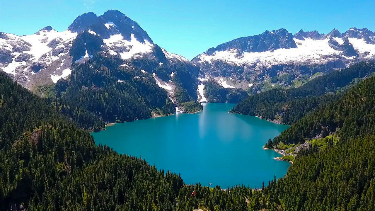
Elfin Lakes hike

- Distance: 20 km
- Duration: 5-7 hours
- Elevation: 812 m
- Difficulty: Moderate
- Trail map
Elfin Lakes is a beautiful hike within the boundaries of Garibaldi Provincial Park.
We did the Elfin Lakes hike in April a few years ago when it was still very snowy, so if you’re hoping to do it without snow then most years you’ll need to wait until late June-July.
I also returned a few years later and did Elfin Lakes all the way out to Mamquam Lake via Opal Cone with a few friends and have spent many a weekend backcountry skiing around Red Heather Hut.
If you’re planning to hike to Elfin Lakes and want to overnight, there’s the cute Elfin Lakes cabin, or you can tent camp at Elfin Lakes too. Just remember to book your camp spot in advance through BC Parks.
While the distance is quite long, there aren’t really any very steep sections of the trail. That means this hike is usually rated easy-moderate in terms of difficulty.
Mt Crumpit

- Distance: 4.7 km
- Duration: 3-4 hours
- Elevation: 263 m
- Difficulty: Moderate
- Trail map
If you’d rather get a view of The Chief than take a hike up it, I’d suggest hiking Mt Crumpit in Squamish. The trails here tend not to be too busy (nowhere near as busy as The Chief anyway!) and you can get a great view in a short distance.
However, do keep an ear out for mountain bikers as this area has many mountain biking trails and you’re not going to want to get in the way!
Slhanay Trail

- Distance: 5.8 km
- Duration: 3-4 hours
- Elevation: 676 m
- Difficulty: Hard
- Trail map
The Slhanay Trail is a Squamish hike that’s been growing in popularity in part due to its fantastic views of the Chief.
Unlike most hikes, the best views on the Slhanay trail aren’t from the summit, rather they’re from a bit further down.
The views are similar to those from Mt Crumpit, but arguably slightly better and the hike is more challenging too.
This trail isn’t the easiest to follow, therefore I strongly recommend downloading the Shlanay trail map from AllTrails and adding it to your phone before leaving for this hike.
Watersprite Lake
- Distance: 19 km
- Duration: 4-6 hours
- Elevation: 736 m
- Difficulty: Hard
- Trail map
Watersprite Lake is quite a drive from Squamish itself on a logging road but you have to go to Squamish first to get there. It’s one of the prettiest hikes near Squamish!
This beautiful lake sits just outside the boundaries of Garibaldi Provincial Park and is maintained by a trail association. It’s a relatively long hike and there’s (very) limited camping at the top as the area around the lake is quite small.
If you do plan on visiting this lake please take extra care not to harm the surrounding ecosystems as it’s very fragile and struggles to cope with the amount of people visiting it at the moment!
If you plan to camp at Watersprite you need to book your tent pad in advance!
Lake Lovely Water
- Distance: 9.8 km
- Duration: 5-6 hours
- Elevation: 1 135 m
- Difficulty: Hard
- Trail map
This is the only one on this list of Squamish trails I haven’t done (yet).
This absolutely stunning lake is harder to get to than the other Squamish hikes on this trail as you first have to book a boat crossing across the Squamish River.
Once you’ve done that it’s a steep hike up to the lake where a refreshing dip awaits!
Brohm Lake hike & the Tantalus lookout


- Distance: 4.8 km
- Duration: 1-2 hours
- Elevation: 176 m
- Difficulty: Easy-Moderate
- Trail map
Brohm Lake and the Tantalus Lookout were a surprise to me.
I’d seen some of Brohm Lake from the highway on the way to Whistler but hadn’t explored the area on foot. One chilly December, I headed out on a solo hike and loved the view of the Tantalus that I got!
There are various loops and trails you can take to reach the Tantalus Lookout and I’d recommend downloading a map on AllTrails (or similar) to make sure you know where you’re going.
The forest around the lake is pretty thick and I imagine it’d be easy to go the wrong way!
Murrin Lake Provincial Park

- Distance: 2.4 km
- Duration: 1-2 hours
- Elevation: 162 m
- Difficulty: Easy-moderate
- Trail map
Murrin Lake gets super busy in the summer with people looking to climb, hike and paddle in the lake. It’s very accessible as the parking lot is right off the highway just south of Squamish.
Though there are plenty of trails to explore, one of the best and most popular trails is to hike the Murrin Loop and Jurassic Ridge trails to Quercus Viewpoint.
Up here there’s a bench and a great view of the Howe Sound and Coast Mountains running alongside the Sea to Sky.
Sea to Summit Trail


- Distance: 11 km if doing out and back, 5.5 km if taking the gondola
- Duration: 4-6 hours
- Elevation: 960 m
- Difficulty: Hard
- Trail map
The Sea to Summit trail is a rewarding hike in Squamish, BC. Sometimes called the Sea to Summit trail or even the Shannon Falls hike, the best part is you can enjoy a gondola ride down! It doesn’t get much better than skipping the return hiking journey!
Following the same trail as The Chief, to begin with, The Sea to Summit trail then splits off. You pass Upper Shannon Falls and climb up to the top Sea to Sky gondola station.
Up here you can enjoy a refreshing cold drink from the cafe or explore some of the other trails. Be sure to check out the suspension bridges for awesome views of Howe Sound and the surrounding Coast Mountains!
Or, if you’re still energetic, take on one of the other hikes accessible from the top of the gondola which are some of the best hikes around Squamish.
Alice Lake trails

- Distance: Varies, 6 km + for the two I mention
- Duration: 2+ hours
- Difficulty: Easy
- Trail map
Alice Lake Provincial Park in Squamish is a great place for anyone looking for easy hikes in Squamish BC.
One of the most popular trails is the Alice Lake Loop Trail, a scenic 6-kilometer loop that takes you around the picturesque Alice Lake. This trail provides a leisurely hike through lush forests and offers stunning views of the tranquil lake.
For those looking for a longer adventure, the Four Lakes Trail is a fantastic option. It’s an 8-kilometer trail which takes you around Alice Lake but also Fawn Lake, Edith Lake, and Stump Lake.
What to pack for hiking
What to pack for this hike depends on what season you’re hiking in.
- Check out my day hike packing list here.
- If you’re hiking in summer you should pack sunscreen, sunglasses, layers, water and bug spray as well as everything in the 10 essentials for hiking list.
- Here is what to wear hiking in hot weather
- Check out this post on the best leggings for hiking or what to wear hiking in summer for more details and my gear recommendations.
- If you’re hiking in winter after the snow has started falling you’ll need microspikes at the very least. If there is a lot of snow you will probably need snowshoes.
- You should also take plenty of layers including a fleece layer, a puffy insulated jacket and a wind and waterproof outer layer. Hats and gloves are also necessary as well as a good backpack to keep everything in.
- You should also pack water and some snacks too to keep you going as they’re part of the 10 essentials for hiking!
- Planning a hiking date? Check out what to wear on a hiking date but still look cool.
FAQs about the best Squamish hiking trails
What to do in Squamish?
Final thoughts on the best hikes Squamish has to offer
If you’re looking to hike Squamish BC, this guide to the best hikes in Squamish is a great starting point. Covering some of the most popular hikes in Squamish such as the Chief and a few lesser-known hikes including Mt Crumpit, this list of the best hikes near Squamish has you covered.
For easy hikes Squamish has to offer, check out the trails near Alice Lakes for some easy hiking trails Squamish has to offer as well as Murrin Lake Provincial Park which offers more options for Squamish easy hikes.
Check out over 100 hiking guides in Vancouver and from around the world.
Last Updated on June 22, 2023 by Hannah

Hannah started That Adventurer after graduating back in 2013 and has documented all of her adventures since then. From backpacking South America to city breaks in Europe, a 3 month road trip across the USA in a self-converted van and 6 years living in Canada, you’ll find posts on all of this.
Hannah specialises in active travel and on That Adventurer you’ll find hiking, walking, biking, skiing and all sorts of active travel guides to allow you to see a destination in an adventurous way.
Now back in Europe, you’ll find new guides as Hannah and her husband spend the next year ‘digital nomading’ from Norway to Portugal, Switzerland to Scotland and places in between.


