The incredible Skookumchuck Narrows on the Sunshine Coast BC!
Visiting the Skookumchuck Narrows is one of the best things to do on the Sunshine Coast BC.
It’s such a unique thing to see and is a highlight of our trip to this part of the Sunshine Coast.
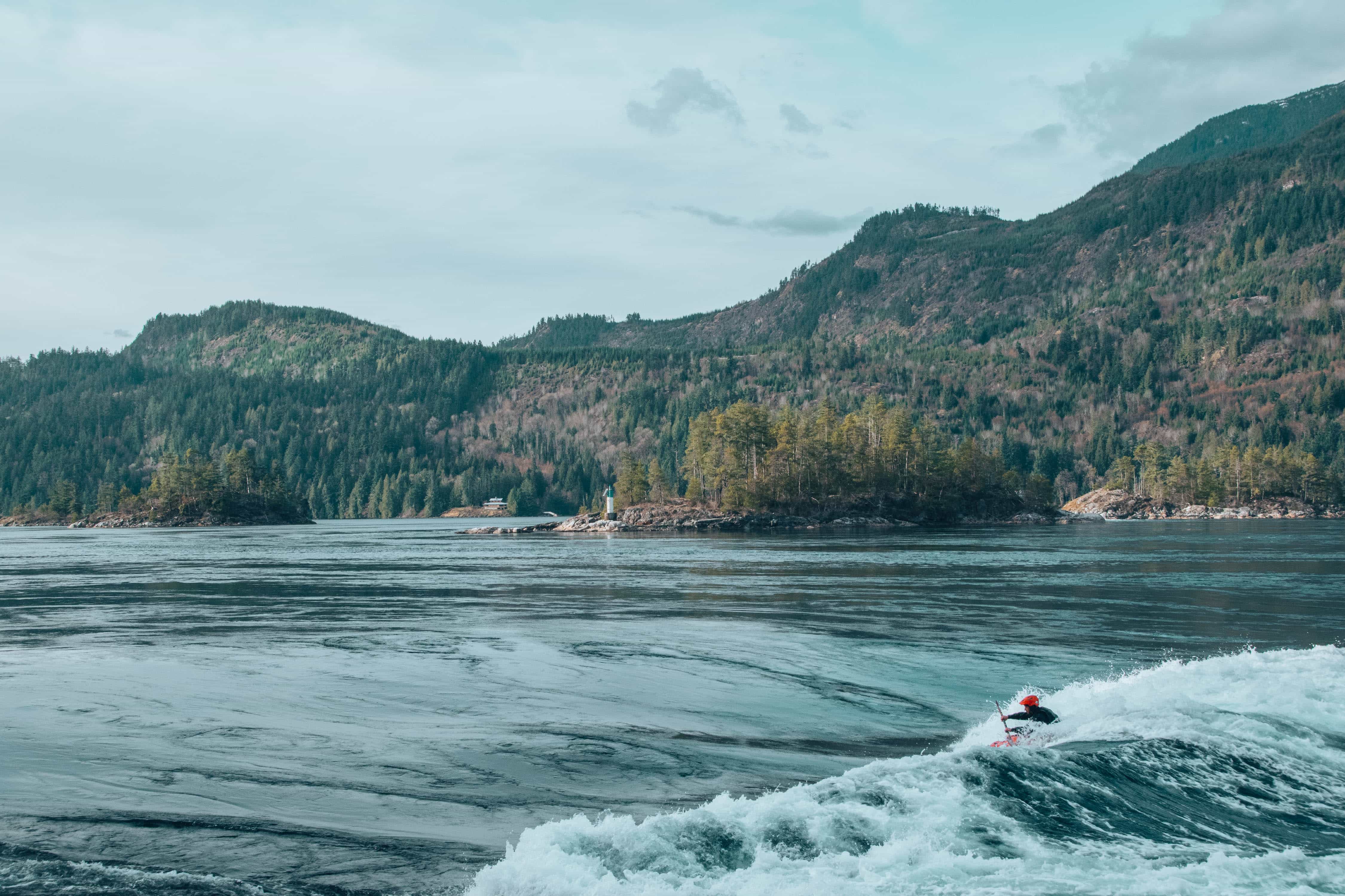
At Skookumchuck Rapids, twice a day the waters become rapids which people kayak on. The rapids are huge and seriously impressive and you can watch from the side as the kayakers take on these rapids after an easy hike through the forest.
AllTrails is my go-to hiking app for finding, planning, and navigating while I’m out on the trails. With offline maps on AllTrails+ you can be confident you’re still on the right track, even without mobile signal.

Hiking the Skookumchuck Narrows
The Skookumchuck Rapids are an easy 4 km hike away from the parking lot. It’s a pretty flat trail and will take you about an hour to walk.
We headed to this part of the Sunshine Coast during a long weekend and have been back several times since, cause it’s just so cool to watch!
We’d already hiked Soames Hill and Pender Hill and then were prepared to explore some of the lakes and Cliff Gilker Park the following day. However, this was easily one of our favourite things.
The trail begins from a small car park area near Egmont. There are plenty of signs as you travel up the Sunshine Coast so you shouldn’t have any problem finding them!
Head down the gravel road and across a short bridge. After walking for 10-15 minutes you’ll come across a metal gate on your right with a sign that marks the beginning of the trail to Skookumchuck Narrows.
This tail takes you into the forest and is easy to follow.
You’ll come across Brown Lake and it’s here you’ll officially enter Skookumchuck Narrows Provincial Park.
As you continue you’ll reach a junction where you can go either left to North Point or right to Roland Point. Depending on the time you can visit both.
Make sure you’ve checked the tide charts beforehand!
North Point

The view from North Point is set on some rocks, higher up and looks across the narrow waterway. Hikers can sit on a single bench or along the rocks to enjoy the view. The area is surrounded by a fence to prevent anyone from venturing too near the dangerous whirlpools.
Roland Point
The view from Roland Point is closer to the water and more open. There is not an obvious place to sit but plenty of space to enjoy the views of the rapids. You can get right next to the water but please ensure to not venture too close as the currents are very strong during the tidal changes.
After enjoying the views of the area, hike back along the trail in the direction you arrived, passing the junction and heading up the gradual hill through the forest.
Pass Brown Lake and continue to enjoy the calmness and smells of the forest.
Once back at the gravel road, follow it back towards the parking area as you cross back over the bridge and make the final few steps of your return.
Skookumchuck Narrows hike stats
- Difficulty: Easy
- Distance: 8km
- Time: 1.5-2hours
- Elevation: pretty much none
Best time to view the narrows
The best time to visit the narrows is documented in this skookumchuck narrows tides 2024 schedule. You don’t need to be there at the precise time. There’s a 30-minute window on each side.
About the Skookumchuck Narrows
The narrows form part of the Sechelt Provincial Forest which covers over 123 hectares and has plenty of trails to explore.
The word “Skookumchuck” comes from a Chinook word meaning turbulent water or rapid torrent. It makes total sense when you see what the Skookumchuck Narrows look like at the right tide.
Twice a day the tide changes and the flow of saltwater switches which reverses the direction and power of the water. Sometimes the water can reach 9ft in height!
The rapids are best viewed at peak low tide, whereas the whirlpools are best seen at peak high tide.
Where to view the rapids and whirlpools from
There are two viewing points. The first looks out at the whirlpools from quite far away (North Point) and the second is Roland Point which is closest to the rapids themselves. This is where the kayakers launch from and where you’ll get the best view of them.
Last Updated on December 28, 2023 by Hannah

Hannah started That Adventurer after graduating back in 2013 and has documented all of her adventures since then. From backpacking South America to city breaks in Europe, a 3 month road trip across the USA in a self-converted van and 6 years living in Canada, you’ll find posts on all of this.
Hannah specialises in active travel and on That Adventurer you’ll find hiking, walking, biking, skiing and all sorts of active travel guides to allow you to see a destination in an adventurous way.
Now back in Europe, you’ll find new guides as Hannah and her husband spend the next year ‘digital nomading’ from Norway to Portugal, Switzerland to Scotland and places in between.


it looks absolutely stunning! You shared great things to do there! Great article. Thank you so much for sharing a great post!