
Best hikes in North Cascades National Park Wa
There are so many awesome hikes deserving of being given the title of best hikes in North Cascades National Park Washington.
This gem of a National Park was one of my favorite National Parks we visited during our three-month America trip and luckily we were able to go back multiple times since we lived just across the border in Vancouver, BC.
The North Cascades is sometimes referred to as “The American Alps” and you’ll soon understand why when you visit. It’s full of glacial mountain peaks, forests, and lakes.
The terrain is quite rugged and because of this a lot of the hikes are on the more moderate/strenuous side.
You have to work for the most impressive views on a North Cascades hike! But, don’t fear there are some easy day hikes in the North Cascades, Washington that’ll get you great views too such as the Thunder Knob trail, amongst others.
It’s no exaggeration to say that one of the best things to do in North Cascades National Park is to go hiking – you’ll see what I mean!
Note: Always check trail closures and information before heading out on these hikes as they’re subject to road closures all year round due to snow/fire.

Best hikes in North Cascades National Park
Whether you’re looking for day hiking in the North Cascades or backcountry, here are a few ideas to get you started on the North Cascades National Park’s best hikes.
North Cascades National Park hiking Map
Below you’ll find both the National Park Service map of North Cascades National Park as well as my own map I’ve put together which shows you the best things. todo in the north Cascades as well as where to stay and some of the best hikes.
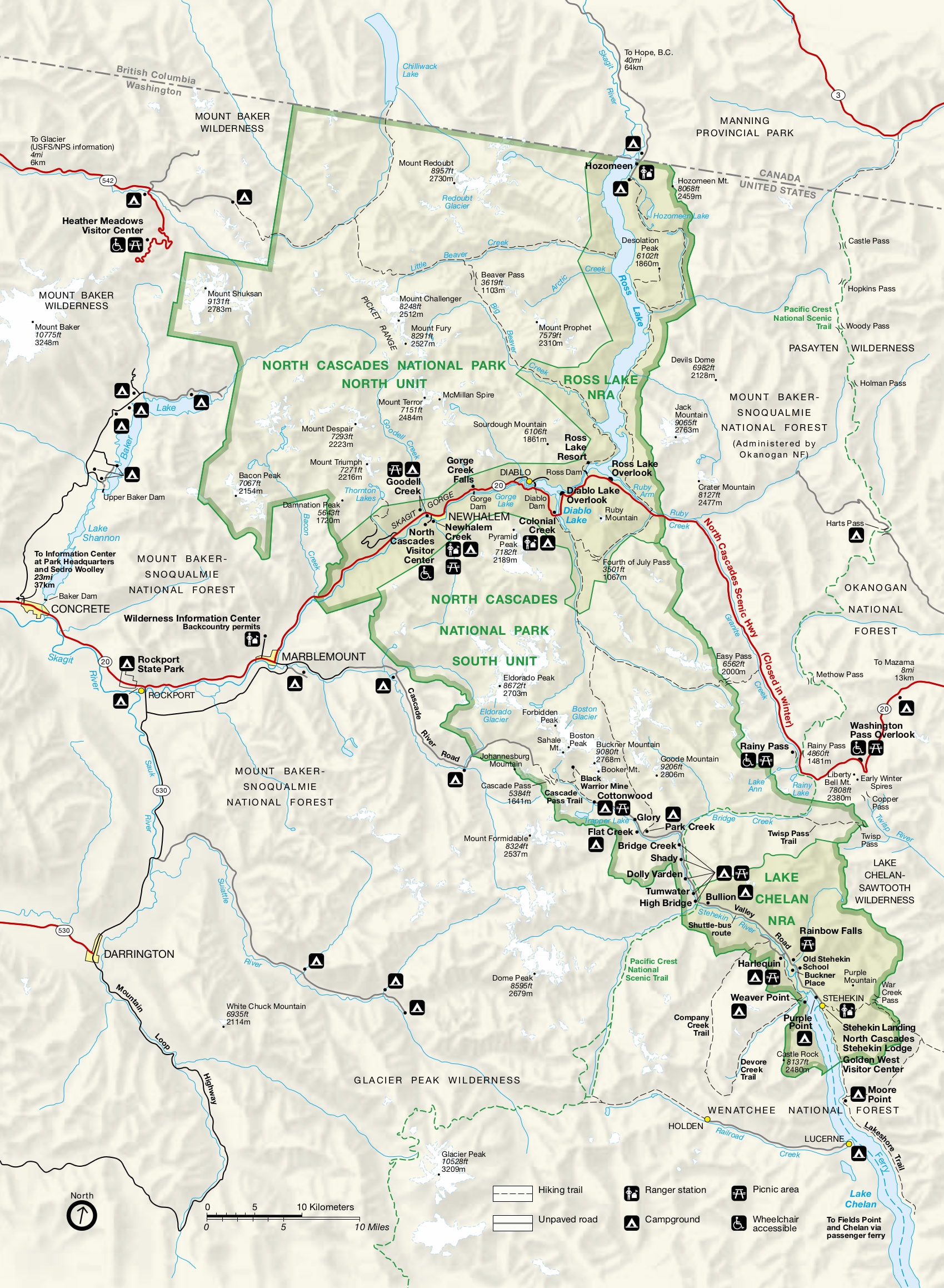
This map of North Cascades National Park gives you an idea of the size of the park. If you’re looking for a North Cascades Trail Map you can pick up a very basic one (like the image above) at the visitor center within the park.

Simply click on the map above to open it up as an interactive Google map and use it to plan your hiking trip to the North Cascades in Washington.
Alternatively, I like to use the Alltrails app to do some quick research into hikes and routes and carry a proper trail map with me (like this North Cascades map) when going on a longer hike.
You can see a North Cascades highway map – which is the road running through the park from east to west – here.
AllTrails is my go-to hiking app for finding, planning, and navigating while I’m out on the trails. With offline maps on AllTrails+ you can be confident you’re still on the right track, even without mobile signal.
Get a North Cascades trail map
If you’re planning on doing any of the more strenuous hikes and especially if you’re backpacking, you should take a North Cascades National Park trail map with you as well as a compass and know how to navigate.
The North Cascades National Park trails aren’t all well marked so you’ll need to know where you’re going without relying on markers.
These trail guides for the North Cascades are useful for both information and when you’re out in the mountains too.
- North Cascades National Park topographic map by National Geographic
A guide to more than 100 great hiking adventures in the North Cascades
AllTrails is my go-to hiking app for finding, planning, and navigating while I’m out on the trails. With offline maps on AllTrails+ you can be confident you’re still on the right track, even without mobile signal.

Best day hikes in North Cascades National Park
Take a look at these North Cascades day hikes if you’re only visiting for one day or are short on time.
We did the Thunder Knob trail which doesn’t take too long and allows for plenty of time exploring the rest of the park on a North Cascades day trip but there are a lot of choices when it comes to North Cascades National Park hikes!
We went back a few years after our first visit to the North Cascades and did some of these other hikes too.
Thunder Knob Trail
- Distance: 3.4 miles / 5.5 km
- Duration: 1.5 – 2 hours
- Difficulty: Easy/Moderate
- Elevation: 676 ft / 206 m
- Trail map
The Thunder Knob Trail is a must-do for those eager to capture breathtaking views of Diablo Lake’s vibrant blue color.
As a beginner-friendly hike, it’s an excellent choice for families and pets too, and even though it’s not a high-altitude trek, the panoramas of Diablo Lake, Sourdough Mountain, and the snowy Davis Peak won’t disappoint.
Since the trailhead is near the campground, it can get crowded. I’d recommend an early start to make sure you get parking and enjoy the trail when it’s less busy.

Sterling Munro Trail
- Distance: 0.3 miles / 0.5 km
- Duration: 10 mins
- Difficulty: Easy
- Elevation: None
- Trail map
If you’re looking for a brief yet scenic walk, the Sterling Munro Trail is the answer.
Starting from right behind the Rockport Park visitor center, this trail has an accessible boardwalk from which you can enjoy some incredible mountain views down the valley.
This is an easy hike in the North Cascades National Park which is ideal for families, children can safely run on the boardwalk.

Trail of the Cedars
- Distance: 0.8 miles / 1 km
- Duration: 15 mins
- Difficulty: Easy
- Elevation: None
- Trail map
Taking a stroll on the Trail of the Cedars trail in North Cascades National Park is one of the best easy hikes in the park.
This trail is in the Newhalem area and it’s an easy loop trail that treats you to sights of the Skagit River and a forest reminiscent of Olympic National Park’s temperate rainforests.
There’s also a suspension bridge over the Skagit River and you can enjoy the beautiful ancient forest teeming with cedars, firs, and ferns.

Gorge Creek Falls Trail
- Distance: 0.5 miles / 0.8 km
- Duration: 10 mins
- Difficulty: Easy
- Elevation: Minimal
- Trail map
Every trip to the North Cascades needs a waterfall walk!
One of the easiest walks and most impressive for the little amount of effort required is the Gorge Creek Falls Loop Trail.
Suitable for younger kids, this hike is flat and easy to walk and though it’s not the most wowing trail in the park, it’s still worth hiking if you’re looking for something low-key and easy.

Ladder Creek Falls
- Distance: 0.5 miles / 0.8 km
- Duration: 15 mins
- Difficulty: Easy
- Elevation: 72 ft / 22 m
- Trail map
Pretty close to the trailhead for the Trail of the Cedars and the Gorge Powerhouse, is another of the best hikes in North Cascades National Park which is easy and worth doing alongside the Trail of the Cedars.
As you do the hike to Ladder Creek Falls you’ll walk over boardwalks, bridges, and enjoy a spectacular waterfall view.
Despite its short length, it does have steep parts, but it’s manageable with steps and handrails and it’s pretty short so you won’t be climbing for long!

Blue Lake Trail
- Distance: 4.6 miles / 7.4 km
- Duration: 2 – 2.5 hours
- Difficulty: Moderate
- Elevation: 915 ft / 279 m
- Trail map
The Blue Lake Trail is an excellent addition to your North Cascades itinerary.
It’s a moderate hike with a gentle elevation gain of under 1000 feet, making it accessible for hikers of all ages and abilities.
The trail guides you through an old-growth forest, eventually leading to the brilliant Blue Lake, which has some super impressive granite peaks as a backdrop.
If you want, you can walk around the lake too to fully soak in the views.
Arguably the best time to hike the Blue Lake Trail is in Fall. That’s because you get to witness the incredible yellow larch trees which are super cool to see. Or, if you’re visiting in summer, pack your swimsuit and take a dip!

Diablo Lake Trail
- Distance: 4.6 miles / 11.6 km
- Duration: 1 hour
- Difficulty: Moderate
- Elevation: 915 ft / 460 m
- Trail map
The stunning Diablo Lake Trail in the North Cascades takes you through forests, over dry rocky areas, and along the edge of the breathtaking emerald-green lake.
It takes about 1 hour to hike, and the trail has some elevation gain but nothing too hard.
The trailhead starts near the ferry terminal and ends up by the Ross Lake Dam before you return the way you came.
You won’t get to Diablo Lake Vista Point on this trail, but you will see the lake from new and gorgeous angles that you can’t get from the highway.
It’s a top choice if you’re looking to get a different perspective on one of the park’s most famous lakes.

Rainy Lake
- Distance: 2 miles / 3.2 km
- Duration: 45 mins
- Difficulty: Easy
- Elevation: 131 ft / 40 m
- Trail map
Rainy Lake is the ideal hike for families or those looking for a relaxing walk. It’s a short, 2-mile round trip trail that’s flat and paved, making it easy to walk on with no roots and rocks to step over.
It’s a fairly peaceful walk and you’ll come out to Rainy Lake which is absolutely beautiful with clear blue waters and an incredible mountain backdrop.
After your leisurely hike, if you’re up for more sightseeing, continue down the scenic Highway 20 and make a stop at the Washington Pass Overlook for more stunning views.

Cutthroat Lake
- Distance: 3.8 miles / 6.1 km
- Duration: 1.5 hours
- Difficulty: Easy
- Elevation: 479 ft / 146 m
- Trail map
Cutthroat Lake is perfect for a relaxing and easy hike in North Cascades National Park.
The trail is mostly flat, leading you through a peaceful, lush forest and one of the best parts of this hike is crossing a log footbridge.
Though some might say it’s not as pretty as Blue Lake, Cutthroat Lake is still a beautiful spot, with calm waters surrounded by forested hills.

Cutthroat Pass
- Distance: 11.4 miles / 18.3 km
- Duration: 5 – 6 hours
- Difficulty: Hard
- Elevation: 2 474 ft / 754 m
- Trail map
For those seeking a more challenging and rewarding hike, Cutthroat Pass is a fantastic option.
While this hike is technically just outside of North Cascades National Park in the Okanogan-Wenatchee National Forest, it offers some of the most stunning views you can find in the area.
You can approach the pass from two different directions: one option involves jumping on the Pacific Crest Trail from the west via the Maple Pass Trailhead, and the other begins at the Cutthroat Trailhead on the east side of the pass, going via Cutthroat Lake.
The route detailed above includes the lake and pass from the eastern trailhead.
Whichever route you choose, the views are spectacular, with expansive landscapes that are especially breathtaking in September when the larch trees turn a blazing golden yellow and the mosquitoes have mostly disappeared.

Sourdough Mountain
- Distance: 10.2 miles / 16.4 km
- Duration: 5 hours
- Difficulty: Hard
- Elevation: 5 089 ft / 1 551 m
- Trail map
Sourdough Mountain is for the ambitious hiker looking for a challenge.
It’s a longer hike that climbs a steep 5,000 feet, so it will really test your legs and lungs!
Starting in a lush forest, you’ll navigate a series of switchbacks (zig-zagging paths) that lead to open, flower-filled meadows.
Then, at the top, you’ll find a historic fire lookout station where you’re rewarded with sweeping views of Diablo Lake and, on clear days, the distant Mount Baker.
Remember to pack lots of water for this hike – you’ll need it!

Rainbow Loop
- Distance: 8.7 miles / 14 km
- Duration: 5 hours
- Difficulty: Moderate
- Elevation: 2 293 ft / 699 m
- Trail map
Rainbow Loop is one of the best North Cascades hikes for hikers exploring the Stehekin Valley, part of the Lake Chelan National Recreation Area.
The 9-mile trail, rated as moderate, offers you panoramic views of Stehekin Valley, Lake Chelan, Rainbow Creek, and vibrant wildflowers amidst the surrounding mountains at certain times of the year.
To reach the trailhead you’ll need to take a ferry trip to Stehekin, then a shuttle to the trailhead.

Thornton Lakes Trail
- Distance: 9 miles / 14.5 km
- Duration: 5 – 6 hours
- Difficulty: Hard
- Elevation: 3 005 ft / 916 m
- Trail map
- Note: You will need a 4×4 or vehicle with high clearance to get to the trailhead
This iconic North Cascades hiking trail leads to the picturesque Thornton Lakes and Trappers Peak.
It starts gently through the forest, but after four miles of switchbacks, you can decide whether to descend to Thornton Lakes or ascend to Trappers Peak.
The climb to Trappers Peak is challenging yet rewarding as you’ll get 360-degree views of the Picket Range, Thornton Lakes, and far-off vistas like the Skagit River and Newhalem.
However, if you’re feeling hot and tired, then go down to Thornton Lakes for a quick and refreshing dip!
This hike is a perfect day hike but can also be extended to an overnight trip with a permit.

Cascade Pass and Sahale Arm
- Distance: 11.6 miles / 18.7 km
- Duration: 7.5 hours
- Difficulty: Hard
- Elevation: 3 963 ft / 1 208 m
- Trail map
Cascade Pass and Sahale Arm is one of the best hikes in North Cascades National Park. It is a hike that rewards you with pretty much every step you take as the views get even more beautiful.
You’ll walk through the forest into open meadows, and then reach the pass where you’ll be surrounded by towering peaks.
For the more adventurous, extending the hike to reach the Sahale Glacier is an absolute must. This stretch is steeper and more challenging but offers a close-up look at glacial formations and sweeping views of Doubtful Lake and numerous jagged, snow-capped peaks.
The Sahale Glacier Camp, an exposed ridge above the glacier, is the final destination for most, and it’s easy to see why—here, the views stretch in every direction and are nothing short of incredible.

Maple Pass Loop North Cascades
- Distance: 6.5 miles / 10.5 km
- Duration: 4 hours
- Difficulty: Hard
- Elevation: 2 162 ft / 659 m
- Trail map
Maple Pass Loop is a great trail in the North Cascades that starts at the Lake Ann Trailhead.
I’d recommend hiking the loop counter-clockwise, as this offers a more gradual ascent and puts the best views towards the end of the hike so you’ll have something to look forward to as you climb up.
The Maple Pass trail takes you through lush old-growth forests, past Lake Ann, and up to a high ridge with panoramic views of the rugged North Cascades. In autumn, the golden larches contrast beautifully with the deep blues of Lake Ann and the surrounding snow-capped peaks, making for an unforgettable sight.

Easy Pass
- Distance: 7.7 miles / 12.4 km
- Duration: 5 – 5.5 hours
- Difficulty: Hard
- Elevation: 2 923 ft / 891 m
- Trail map
The Easy Pass trail is a challenging yet rewarding hike, and the name might give you a chuckle once you’ve completed it. It’s definitely not an easy hike!
Though the hike starts relatively easily, crossing Granite Creek and through a forest of firs and hemlocks, you’ll then go through some beautiful meadows after which the work begins!
You’ll make your way up a series of switchbacks that climb steeply up to Easy Pass.
The pass itself is a high, alpine meadow offering sweeping views of the surrounding rugged peaks and valleys.
What makes Easy Pass one of the best North Cascades hikes is that it offers continuous, stunning views almost the entire way.

Hidden Lake Trail
- Distance: 8.7 miles / 14 km
- Duration: 5 – 6 hours
- Difficulty: Hard
- Elevation: 3 707 ft / 1 130 m
- Trail map
- Note: The road to the trailhead is rough and requires a high-clearance vehicle
The Hidden Lake trail takes you through some gorgeous North Cascades meadows and over rock terrain until you come out at the Hidden Lake Lookout.
This lake is deserving of its name since it’s hidden away in between the peaks of the North Cascades.
This trail gives you panoramas of Sahale, Forbidden, and Boston peaks that make you feel as though you’ve reached the summit of the world!
You should be prepared for a challenge; this trail gains over 3500 feet of elevation in just over 4 miles, making for a steep and continuous ascent.

Desolation Peak
- Distance: 8.7 miles / 14 km
- Duration: 7 – 7.5 hours
- Difficulty: Hard
- Elevation: 4 534 ft / 1 382 m
- Trail map
Desolation Peak is a hike with a lot of literary history and jaw-dropping views.
In 1956, author Jack Kerouac spent a summer atop this peak as a fire watchman, an experience he later wrote about in his book “Desolation Angels”.
This challenging trail offers sweeping views over the park, including sights of Skagit Peak, Little Jackass Mountain, and the expansive Ross Lake.
To begin your hike, either cross Ross Lake by boat or commit to an additional 16-mile trek on the East Bank Trail.
From Ross Lake to Desolation Peak, prepare for a steep, challenging climb as you make your way up to the peak!

What to know about North Cascades Backpacking
If you want to take your hiking in North Cascades National Park one step further then go backpacking! There’s a huge amount of backpacking you can do in the North Cascades National Park.
You can do everything from 1-night trips to multi-day expeditions through valleys and over mountain passes.
In the wilderness areas of the park, there are around 140 designated sites. Each camp has a flat tent pad area, pit toilet, and access to water.
You can also do cross-country camping in certain areas as long as you’re at least 0.8km away from designated camps, not in an alpine meadow or fragile vegetation or near water sources.
Cross-country North Cascades camping is usually only done by mountaineers due to the terrain type and experience needed.
Backcountry permits for backpacking the North Cascades
Permits are required all year for overnight stays in the backcountry of North Cascades National Park, Ross Lake, and Lake Chelan.
Permits are specific to a site or a cross country zone and you must follow the itinerary listed on your permit.
How to Get a Backcountry Permit
You can get a backcountry permit for the North Cascades either through advanced reservation (this holds a site but needs to be converted to a permit before entering the park) or through getting a walk-up permit.
Permits must be picked up at a ranger station in or around the park.
60% of permits are advanced permits and they are allocated in full very quickly each year.
If you don’t have a permit for the coming year but still want to explore the backcountry you can, but you’ll likely have to do a less popular trail.

Backcountry hikes in the North Cascades
Backcountry hikes in the North Cascades can generally be split into a few categories. There are the cross-park treks, hikes in the Stehekin area, and loops and other long hikes.
AllTrails is my go-to hiking app for finding, planning, and navigating while I’m out on the trails. With offline maps on AllTrails+ you can be confident you’re still on the right track, even without mobile signal.
North Park Unit
This hike crosses three mountain passes (Hannegan, Whatcom, and Beaver) and follows creeks and rivers through old-growth Western Red Cedar trees from the north end of the park to the south.
If you’re looking to get away from people then this trail could be a good option as it covers areas of the park that sees the lowest trail density.
Fisher Creek/Thunder Creek/Park Creek Pass/Cascade Pass
This trail zigzags from Granite Creek on the dry east of the park to the glacier-covered west of the North Cascades As you hike this trail you’ll go through glaciated valleys, cascading mountain creeks, and rivers.
Stehekin backcountry hiking
Stehekin settlement is not connected by road and you can only get there by hiking, bike and flat plane. There’s a huge amount of North Cascades hiking you can do in and around Stehekin.
Stehekin via McAlester Pass & McAlester Lake
This trail in the Stehekin area takes you through a broad, flat pass with wildflowers in the alpine meadows and goes along some of the PCT too.
It takes in the following trails: Bridge Creek, McAlester Lake, Rainbow Creek, and Rainbow Loop.
Thunder Creek to Pass Creek Pass
Thunder Creek is the most glaciated drainage in the park and this pretty trail goes up through an alpine meadow below the imposing Buckner Mountain and Thunder Glacier.

Awesome hikes in the Mount Baker Area, Washington
You’ll need a Northwest Forest Pass to park at most of these trailheads. If you already have an annual Parks Pass you can use that instead.
Even though it’s not technically part of the North Cascades National Park, the Mount Baker area is one of my favorite areas near the North Cascades National Park for hiking. It’s a wild, remote place that feels just as rugged as the park itself.
- Artist Point: This is a gorgeous trail with awesome panoramic views of Mt. Baker and Mt. Shuksan that are unforgettable. It’s also a great snowshoe!
- Skyline Divide: At the top of this hike, you’ll be rewarded with spectacular, sweeping views of Mt. Shuksan, Mt. Kulshan, and distant peaks of the North Cascades.
- Heliotrope Ridge Trail: a famous route for a good reason. This 5.4-mile round trip hike, with an elevation gain of 1,400 feet, takes you through lush forest, past rushing creeks and waterfalls, and leads to breathtaking views of the Coleman Glacier on Mt. Baker. As you ascend, you’ll be surrounded by wildflowers and, eventually, reach a vantage point that offers stunning sights of Mt. Baker and the glacier.
- Ptarmigan Ridge Trail: This trail lets you get up close and personal with Mt. Baker and provides awe-inspiring views of the mountains around it. This trail was our top pick for this area, and it was disappointing that we couldn’t hike it this time.
- Table Mountain: This trail takes you up steep paths to the summit of Table Mountain, where you’ll enjoy panoramic views of the surrounding area.

What to know before hiking in North Cascades National Park Washington
Before hiking in North Cascades National Park, it’s essential to know that it’s a wild and rugged place, so preparation is key. Make sure you have a solid plan and the right equipment. Here’s what you need to know:
- Check the North Cascades National Park weather forecast before you go: The weather can change quickly in the mountains, and it can be drastically different from the lower elevations. Dress in layers and be prepared for anything from sun to rain or snow.
- Know your fitness level: The trails in the North Cascades range from easy walks to strenuous climbs. Make sure to choose a hike that matches your fitness level and experience.
- Bring plenty of water and snacks: You’ll need to stay hydrated and fueled. There is often no source of potable water along the trails.
- Wear proper footwear: Hiking boots that provide ankle support and have good tread are essential. This isn’t the place for sandals or casual shoes.
- Pack the ten essentials: These include a map, compass, sunscreen, extra clothing, flashlight, first aid kit, matches, knife, and extra food.
- Keep wildlife wild: If you encounter animals, give them plenty of space and don’t feed them. Store food properly to avoid attracting them to your campsite.
- Stay on the trail: To protect the environment and yourself, it’s important to stick to the established trails.
- Check trail conditions and closures: Before you head out, visit the park’s visitor center or website to get the latest information on trail conditions, closures, and any alerts or warnings.
- Get a permit if you plan to camp: If you’re planning on staying overnight in the backcountry, you will need a permit. These can be obtained at the park visitor center.
- Leave No Trace: Pack out all of your trash and leave the places you visit just as you found them. Follow the Leave No Trace principles to help protect these beautiful areas.
- Timing is key: Snow can linger on high-elevation trails well into the summer. The most popular hiking months are July through September, but trails can be crowded then. Consider visiting in the shoulder seasons for fewer crowds.
- Be prepared for bugs: In the summer, especially near water, mosquitoes, and flies can be abundant. Bring insect repellent.
- Tell someone your plans: Before you set out, let a friend or family member know your itinerary and when you expect to be back. It’s a simple safety measure that should not be overlooked.
- Remember, North Cascades National Park is a remote and wild place. Cell phone service can be spotty or nonexistent, so don’t rely on your phone for navigation or communication during your hike.
By following these tips, you’ll be setting yourself up for a safer and more enjoyable adventure in North Cascades National Park.

What to pack for hiking in North Cascades Washington
Here is a packing list for the North Cascades National Park. Of course, your list may vary depending on your personal preferences and your hiking plans.
- Weather-appropriate clothing: Dress in layers to adjust as the weather changes, and include a waterproof and windproof jacket for sudden downpours or wind.
- Hiking boots or trail shoes: Ensure they are comfortable and broken in to avoid blisters.
- Backpack: Choose a durable and comfortable backpack to carry all your essentials for the hike.
- Water: Stay hydrated during your hike, as sources of potable water can be limited along trails.
- Snacks and food: Pack energy bars, nuts, and other nourishing items to maintain your energy levels during the hike.
- Map and compass: Cell service can be unreliable in the park, making these tools vital for navigation.
- Sunscreen and sunglasses: High elevations can mean intense sun exposure; protect your skin and eyes.
- First aid kit: Be prepared for minor injuries with bandages, antiseptic wipes, and blister treatment.
- Headlamp: An essential item if you get caught out after dark; pack extra batteries too.
- Matches or lighter and a small stove: Useful for cooking food when fires are not allowed in the backcountry.
- Knife or multitool: Handy for food preparation, first aid, and other unexpected needs.
- Extra food: Pack additional nourishment in case your hike takes longer than anticipated.
- Emergency shelter or bivy: An essential safety item for unexpected overnight situations.
- Insect repellent: Keep bugs at bay, especially during the summer months near water sources.
- Camera or smartphone: Capture the stunning views, but remember that charging can be a challenge.
- Permits and identification: Ensure you have the necessary permits for camping and a form of ID on you at all times.
- Personal items: Don’t forget prescription glasses, contact lenses, and personal hygiene products for your comfort and health.
Best time to visit North Cascades National Park for hiking
If you’re planning a hiking trip to the North Cascades National Park, it’s important to bear in mind the season as the temperature and trail conditions really vary.
Spring (March – May): Spring in the North Cascades brings milder temperatures, usually ranging from 35°F to 60°F. As snow begins to melt, lower elevation trails become accessible, but many higher-elevation trails remain snow-covered until late spring. Road closures, like the North Cascades Highway (SR 20), usually open in late April or early May, but it varies year to year based on snow conditions.
Summer (June – August): Summer is the prime hiking season in the North Cascades, with temperatures ranging from 50°F to 80°F. Most trails are snow-free by late June or early July. This is the busiest season, so expect more company on the trails. The North Cascades Highway and other roads are typically open during this season.
Fall (September – November): Fall is a spectacular time to hike in the North Cascades, with cooler temperatures ranging from 35°F to 65°F and vibrant fall colors. Early fall is generally dry, but rain increases later in the season. The North Cascades Highway usually remains open until the first significant snowfall, often in November.
Winter (December – February): Winter hiking in the North Cascades is for the experienced and prepared, as temperatures can range from 20°F to 35°F. Most of the higher elevation trails are covered in snow, and many roads, including the North Cascades Highway, are closed for the season. Snowshoeing and skiing are popular winter activities.
North Cascades entrance fees
There’s no fee to enter North Cascades National Park – it’s completely free and no entrance pass is needed! However, there are fees for the ferry and transport to Stehekin. If you’re parking and hiking in the Okanogan-Wenatchee National Forest you will need a forest pass.
Where is North Cascades National Park?
North Cascades National Park is in Washington, USA, and forms part of the Cascade Mountain Range; so-called due to the many, many waterfalls found in it.
The range runs from British Columbia to northern California and it’s believed that the North Cascades mountains as they are today rose up around 5-6 million years ago!
North Cascades National Park is close to the Canada – USA border and is roughly 2.5 hours from both Vancouver, BC and Seattle depending on traffic conditions.
FAQ on the best North Cascades National Park Hiking Trails
Where is the best place to hike in North Cascades National Park?
What is the most popular hike in North Cascades National Park?
What are the best overlooks in North Cascades National Park?
What are the easiest hikes in North Cascades National Park?
What are the hardest hikes in North Cascades National Park?
Final thoughts on hiking in the Northern Cascades National Park
There are so many awesome hikes in North Cascades National Park and it’s easily one of the best things to do in the park.
From the emerald-green lakes to the beautiful snow-capped peaks and lush forests, hiking is the best way to get to know this park.
If you’re planning a trip to Washington, you may be interested in some of my other hiking guides, or these posts on the best things to do in Bellingham, what to do in Seattle, and this guide to the North Cascades accommodations.
Or, perhaps you’re visiting from Vancouver, in which case, take a look at these Vancouver travel guides.
Last Updated on August 15, 2023 by Hannah

Hannah started That Adventurer after graduating back in 2013 and has documented all of her adventures since then. From backpacking South America to city breaks in Europe, a 3 month road trip across the USA in a self-converted van and 6 years living in Canada, you’ll find posts on all of this.
Hannah specialises in active travel and on That Adventurer you’ll find hiking, walking, biking, skiing and all sorts of active travel guides to allow you to see a destination in an adventurous way.
Now back in Europe, you’ll find new guides as Hannah and her husband spend the next year ‘digital nomading’ from Norway to Portugal, Switzerland to Scotland and places in between.


